*Science class: Space age study
|
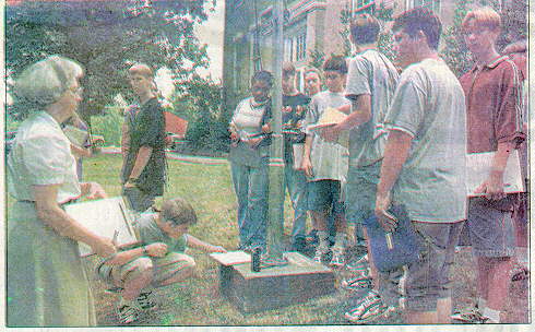
"I wanted them to see that it is something we use every day . . .that every spot on earth is different and identifiable," she said. She started by borrowing a Global Positioning Satellite (GPS) GPS receiver from Henry County High School's Diversified Technology Lab. She explained to her students that there are 24 satellites positioned in permanent locations around the earth. The GPS searches for and must find at least two of those satellites to fix its position. Using several landmarks on the Grove campus, the students learned their positions with the GPS, measuring in degrees, minutes and seconds. "They also found they could figure out the distance they had walked between spots and what direction they were going when they learned the math," said Mrs. Claxton. But to demonstrate how all |
this is useful, she brought professionals to the
classroom who actually use this technology every day. Agronomy specialist
Chester Cocke from Jackson Farmers Cooperative told the students that longitude
and latitude are used in agriculture through the entire process of planting
and harvesting.
Instead of spot collecting soil samples, the samples can now be based on field maps produced with a satellite receiver so that a farmer knows specifically in that field where things such as nutrients or chemicals are needed, he explained. That information can then be programmed into a fertilizer truck's computer system to deliver a number of' different nutrients in specific places instead of blanketing the field with one type. When it's time to plant, GPS-generated yield maps of the previous year may show a need to fertilize differently or plant different varieties within a field, Cocke said. Also, throughout the growing season, a farmer can spot check his field with a handheld GPS unit and enter new data into the computer. |
The trucking industry uses
the
GPS system to route trucks that may be in the vicinity of a manufacturer requesting service, according to Dean Sager, vice president of safety at Paschall Truck Lines in Murray. Sager told the students the units on the trucks also have keyboards so drivers can type and receive information from his office. He said two drivers' lives were saved because they were able to use their keyboards when they were having heart attacks. After receiving the messages, the operator was able to find out where the trucks were because of the GPS unit, call 911 for that area and give them the longitude and latitude of' the truck, he explained. "We think of' longitude and latitude as big lines on a map to find cities and states," said Mrs. Claxton. "But you can find a chair in a room with them. The military originally set up the GPS system for guided missiles. Now, new cars use it for their mapping systems." Donna Newcomb is a freelance writer and former Post-Intelligencer staff writer |
*This is actually part of the geography unit of a World History class.
|
|
|